


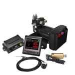


Spend your time ripping through the woods, not waiting on your friends. This rugged powersport GPS navigator keeps your groups in touch and on track.
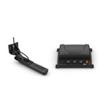
Keep your crew together with group tracking for up to 20 riders, plus push-to-talk fist mic.
Take your side-by-side off the beaten path with topographic mapping, private and public land info, forest service roads and trails.
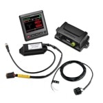
The rugged Tread off-road GPS is IPX7 weather-resistant and features a glove-friendly 5.5” touchscreen display.
Use the Tread app to sync data across your various devices.
Direct-to-device BirdsEye Satellite Imagery can be downloaded to Tread without a computer.
Easily install on your powersport vehicle with the included powered mount and wiring harness with tube mount.
RIDING RADIO FOR GROUP GETAWAYS:
The included Group Ride Radio allows tracking for up to 20 riders with no cellular coverage needed. Plus, the push-to-talk fist mic1 lets you easily stay in communication with your Group Ride friends. Pair Tread with your helmet or headset (not included) enabled with BLUETOOTH® technology for hands-free communication.
OFF-ROAD RUGGEDNESS:
Purpose-built for all-terrain use, Tread stands up to anything the elements can throw at it. It’s IPX7-rated for water-resistance and built to U.S. military standard 810 for thermal and shock resistance.
HIGH-VISIBILITY DISPLAY:
With its ultrabright 5.5” glove-friendly touchscreen, the Tread navigator is designed for easy viewing in bright sunlight or pitch dark. It can be mounted in portrait or landscape mode.
MAPS FOR OFF-ROAD:
Tread features preloaded topographic and street maps of North America with U.S. Forest Service Roads and trails and Motor Vehicle Use Maps for full-sized 4x4s, side-by-side, ATVs and motorcycles.
KNOW YOUR BOUNDARIES:
Access public land boundaries for national forests, Bureau of Land Management (BLM), wilderness areas and more. Also, see private land boundaries and landowner information for parcels greater than 4 acres.
SATELLITE IMAGERY:
Download high-resolution BirdsEye Satellite Imagery directly via Wi-Fi® connectivity, with no annual subscription required.
General:
Physical dimensions:
5.8”W x 3.5”H x 1”D (8.8 x 14.8 x 2.4 cm)
Display size:
4.8”W x 2.7”H (12.1 x 6.8 cm); 5.5” diagonal (13.9 cm)
Display resolution:
1280 x 720 pixels
Display typ:
multi-touch, glass, high brightness HD color TFT with white backlight
Dual-orientation display
Weight :
9.2 oz (262 g)
Battery type:
rechargeable lithium-ion
Battery life:
up to 6 hours (up to 3.5 hours at 100% backlight)
Water rating:
IPX7
Drop rating:
MIL-STD-810
Maps & Memory:
Preloaded street maps:
Yes
Data cards:
microSD™ card
3D Terrain:
Yes
Internal storage:
32 GB
Ability to add maps:
Yes
External memory storage:
Yes
Downloadable Satellite Imagery:
Yes
Sensors:
GPS
Galileo
Barometric altimeter
Compass
Outdoor Recreation:
-Point-to-point navigation
-Preloaded topographical maps
-Preloaded US public land boundaries
-Preloaded private land parcel maps
-Preloaded USFS Roads and Trails, including motor-vehicle-use-maps for motorcycle, ATV, SXS and full-size 4x4
-Navigate-a-track navigation
-Backup camera compatible
Navigation Features:
-Garmin Real Directions™ landmark guidance
-TripAdvisor® Traveler Ratings
-Route shaping through preferred cities/streets
-Includes traffic
-Speed limit indicator (displays speed limit for most major roads in the U.S. and Europe)
-Driver alerts for sharp curves, school zones, red light and speed camera warnings and more
Advanced Features:
-Smart notifications via app
-Wi-Fi® map and software updates
-Access to live services via app (traffic, weather, etc.)
Adventure Features:
-Pair with compatible inReach® devices
-Pair with Garmin PowerSwitch
-Compatible with Group Ride Radio
-Track recorder (breadcrumbs)
-iOverlander™ points of interest
-Ultimate Public Campgrounds
-Pitch and Roll gauges
Group Ride Radio:
Radio Frequency Band - MURS (151-154 MHz)
Group Ride Range - up to 8 mi
Group Ride tracking - up to 20 riders simultaneously
Group Ride update rate - 2.5 sec
Group Ride voice communications - yes (with included fist mic or paired BLUETOOTH headset)
Fist mic compatibility - Also works with other MURS VHF radios (151 MHz - 154 MHz)
Radio transmitted - canned messages
Виж още Морски уреди Garmin
Виж всички Морски уреди в категорията
Keep your crew together with group tracking for up to 20 riders, plus push-to-talk fist mic.
Take your side-by-side off the beaten path with topographic mapping, private and public land info, forest service roads and trails.
The rugged Tread off-road GPS is IPX7 weather-resistant and features a glove-friendly 5.5” touchscreen display.
Use the Tread app to sync data across your various devices.
Direct-to-device BirdsEye Satellite Imagery can be downloaded to Tread without a computer.
Easily install on your powersport vehicle with the included powered mount and wiring harness with tube mount.
RIDING RADIO FOR GROUP GETAWAYS:
The included Group Ride Radio allows tracking for up to 20 riders with no cellular coverage needed. Plus, the push-to-talk fist mic1 lets you easily stay in communication with your Group Ride friends. Pair Tread with your helmet or headset (not included) enabled with BLUETOOTH® technology for hands-free communication.
OFF-ROAD RUGGEDNESS:
Purpose-built for all-terrain use, Tread stands up to anything the elements can throw at it. It’s IPX7-rated for water-resistance and built to U.S. military standard 810 for thermal and shock resistance.
HIGH-VISIBILITY DISPLAY:
With its ultrabright 5.5” glove-friendly touchscreen, the Tread navigator is designed for easy viewing in bright sunlight or pitch dark. It can be mounted in portrait or landscape mode.
MAPS FOR OFF-ROAD:
Tread features preloaded topographic and street maps of North America with U.S. Forest Service Roads and trails and Motor Vehicle Use Maps for full-sized 4x4s, side-by-side, ATVs and motorcycles.
KNOW YOUR BOUNDARIES:
Access public land boundaries for national forests, Bureau of Land Management (BLM), wilderness areas and more. Also, see private land boundaries and landowner information for parcels greater than 4 acres.
SATELLITE IMAGERY:
Download high-resolution BirdsEye Satellite Imagery directly via Wi-Fi® connectivity, with no annual subscription required.
General:
Physical dimensions:
5.8”W x 3.5”H x 1”D (8.8 x 14.8 x 2.4 cm)
Display size:
4.8”W x 2.7”H (12.1 x 6.8 cm); 5.5” diagonal (13.9 cm)
Display resolution:
1280 x 720 pixels
Display typ:
multi-touch, glass, high brightness HD color TFT with white backlight
Dual-orientation display
Weight :
9.2 oz (262 g)
Battery type:
rechargeable lithium-ion
Battery life:
up to 6 hours (up to 3.5 hours at 100% backlight)
Water rating:
IPX7
Drop rating:
MIL-STD-810
Maps & Memory:
Preloaded street maps:
Yes
Data cards:
microSD™ card
3D Terrain:
Yes
Internal storage:
32 GB
Ability to add maps:
Yes
External memory storage:
Yes
Downloadable Satellite Imagery:
Yes
Sensors:
GPS
Galileo
Barometric altimeter
Compass
Outdoor Recreation:
-Point-to-point navigation
-Preloaded topographical maps
-Preloaded US public land boundaries
-Preloaded private land parcel maps
-Preloaded USFS Roads and Trails, including motor-vehicle-use-maps for motorcycle, ATV, SXS and full-size 4x4
-Navigate-a-track navigation
-Backup camera compatible
Navigation Features:
-Garmin Real Directions™ landmark guidance
-TripAdvisor® Traveler Ratings
-Route shaping through preferred cities/streets
-Includes traffic
-Speed limit indicator (displays speed limit for most major roads in the U.S. and Europe)
-Driver alerts for sharp curves, school zones, red light and speed camera warnings and more
Advanced Features:
-Smart notifications via app
-Wi-Fi® map and software updates
-Access to live services via app (traffic, weather, etc.)
Adventure Features:
-Pair with compatible inReach® devices
-Pair with Garmin PowerSwitch
-Compatible with Group Ride Radio
-Track recorder (breadcrumbs)
-iOverlander™ points of interest
-Ultimate Public Campgrounds
-Pitch and Roll gauges
Group Ride Radio:
Radio Frequency Band - MURS (151-154 MHz)
Group Ride Range - up to 8 mi
Group Ride tracking - up to 20 riders simultaneously
Group Ride update rate - 2.5 sec
Group Ride voice communications - yes (with included fist mic or paired BLUETOOTH headset)
Fist mic compatibility - Also works with other MURS VHF radios (151 MHz - 154 MHz)
Radio transmitted - canned messages
Виж още Морски уреди Garmin
Виж всички Морски уреди в категорията
Технически характеристики
| Описание на български: | Не |
|---|---|
| Оригинална гаранционна карта: | Не |
| Гаранция физически лица: | Не |
| Тип: | Аксесоар |
Добави Ревю / Въпрос
Оцени продукта или задай въпрос?
- 5
0 ревюта
- 4
0 ревюта
- 3
0 ревюта
- 2
0 ревюта
- 1
0 ревюта
Свързани продукти
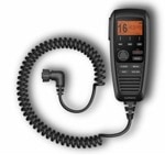
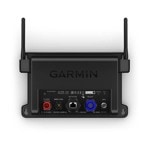
Garmin GHS 11i VHF, IPX7, темп диапазон от -15°C до 70°C
604.77лв
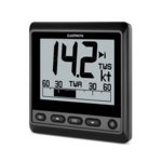
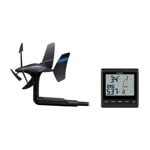
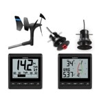
Ветроходен уред Garmin GNX 20 Marine Instrument, подходящ за платноходи, 4.0"(10.16 cm) LCD монохромен дисплей, IPX7 водоустойчивост
789.52лв

Морска аналогова камера Garmin GC 14 (010-02667-00), PAL, видимост при слаба светлина IR до 15 метра, настройка за гледане назад, IPX7 защита
789.52лв